No Products in the Cart
Company
Drone
Quantum Systems Trinity F90+ With Sony UMC
Location
Fort St. John, Canada
Application
Survey & Mapping
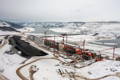
Hydroelectric power provides numerous benefits to surrounding communities while playing a crucial role in the fight against climate change. It is a renewable source of energy relying on water cycles to generate clean energy. Project Managers at BC Hydro's Site C Clean Energy Project, one of the largest construction projects in Canada, have placed their trust in Underhill Geomatics, a Canadian geospatial firm founded in 1913, to track project activities and monitor progress for the Site C clean energy project, a third dam and hydroelectric generating station on the Peace River in B.C. Canada.
Providing 1,100 MW of capacity and producing about 5,100 gigawatt hours of electricity each year, the Site C clean energy project will support enough energy to power the equivalent of about 450,000 homes per year in B.C.
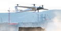
Underhill's role on the Site C project comprises of gathering high quality aerial imagery assets utilizing the advanced Vertical Take-Off and Landing (VTOL) drone from Quantum Systems, the Trinity F90+. Underhill utilizes the Trinity F90+ for tracking and monitoring current infrastructure progress and future planning along with collecting high quality dense point cloud data for aggregate quantity tracking.
The complex project requires multiple and consistent flights to track, monitor and plan large areas of the site so it’s no wonder that one of the Canada's leading geospatial firms, Underhill Geomatics, has turned to Trinity F90+ for their project needs due to its durability and large coverage capabilities amongst other advantages.
"With the Trinity F90+, we have yet to replace a wing or propeller in almost 1000 flights with an average mission length of 45 minutes".
Ryan Schuler
Survey Coordinator at Underhill Geomatics.
Sean Power, Underhill Geomatics (2022)
Moreover, the Canadian Survey Firm utilizes Trinity F90+ to collect orthomosaic photos and point cloud data for additional areas, such as, the Hudson’s Hope Shoreline Protection project and some rock quarrying operations.
The Dam Site is broken into 45 different areas (map tiles). Each map tile has a corresponding flight schedule which depends on the frequency and relevance of work being performed. The project's requirement for data corresponds with the priority and expected changes in a specific area. Expedited processing is performed in high interest areas such as the Dam Core.
Using the Trinity F90+ drone, Underhill obtains a point cloud and volumetric report in only a few hours for high profile areas. The quantity and quality of data would not be attainable without the aid of UAVs, since vertical vantage point is unachievable with traditional survey methods, Underhill says.
"Trinity F90+ Vertical take off and landing (VTOL) feature has allowed for very reliable takeoff & landing procedures in varying weather conditions and locations," Schuler said. "The worksite has been very dynamic, meaning that large, smooth landing zones have been difficult to maintain. The VTOL capability has reduced our maintenance costs significantly".
Underhill has several years of experience in operating unmanned aerial vehicles in some of Canada's harshest conditions. After several years of using competing fixed-wing drones, Underhill decided to make the change to the Trinity F90+ based on the premise of long flight times, reliable vertical take-off and landing, and affordable price point. After using a Trinity F90+ for over a year, Underhill had proved the business case for improved performance over previous fixed-wing drones and added several more to their fleet.
For this project, Underhill has opted to integrate the Sony UMC camera to the Trinity F90+ which features an accuracy expectation around 3-4 cm. Utilizing the included PPK module and their Trimble receivers as base stations, they are able to achieve high-accuracy imagery even at Transport Canada's ceiling of 400 feet AGL.
With large terrain variations and tall structures such as towers and cranes, terrain following is the safest option allowing the drone to adjust the flight altitude for every sweep and achieve a consistent GSD.
At Underhill, three computers are dedicated for processing UAV data. Processing time depends on the size of the map tile. The workflow is as follows:

"When compared to our previous fixed-wing UAV, we can cover roughly three times the ground area with the Trinity F90+ in a single flight. Maintenance costs have been minimized, while productivity has doubled".
Ryan Schuler
Survey Coordinator at Underhill Geomatics.
Ryan Schuler
Survey Coordinator at Underhill Geomatics.
Sean Power, Underhill Geomatics (2022)