+1 866 300 9012   contact@measur.ca
SHOPPING CART

No Products in the Cart

TOTAL:
$0.00

Airborne, High-Accuracy Bathymetric LiDAR

Sale Off
YellowScan Navigator

YellowScan Navigator

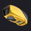
The YellowScan Navigator is a bathymetric LiDAR system for high-accuracy topographic mapping of shallow water. With an integrated INS and embedded camera, the Navigator is a lightweight green laser LiDAR system with a wide swath for large area data collection.

100 m

AGL Altitude

3 cm

System Precision

3 cm

System Accuracy

3.7 kg

Battery Weight Excl.

Bathymetric & Topographic LiDAR Solution

YellowScan has developed an innovative and ground-break solution for underwater topography mapping with a single-button operation. Light enough to be mounted on a variety of UAV's, the Navigator is a versatile platform at an affordable price point.

Detailed Specs

Precision3 cm (1.2")

Accuracy: 3 cm (1.2")

Typ. flight speed: 5 m/s

Max. AGL altitude100 m

Laser rangeUp to 120 m

Laser scannerYellowScan development

GNSS-Inertial solutionSBG Quanta Micro

Echoes per shotUp to 10

Shots per secondUp to 20 000

Scanning frequencyUp to 50 Hz

Weight3.7 kg (8.2 lbs) battery excl.

Size: L 350 x W 160 x H 190 mm

Autonomy45 min. typ.

Power consumption120 W

Operating temperature0° to +40 °C

Nominal ocular hazard distance25 m

Laser classClass 3B

High Performance LiDAR


The Navigator was optimized for bathymetric survey applications and features over 45 minutes of autonomy on a single battery. This allows for large area data collection of rivers, oceans, lakes, and more.
44° FOV for Faster Data Collection
Featuring a 44-degree field of view, the Navigator provides better precision over a broader angle allowing operators to collect more diverse datasets. This 44 degrees is the maximum angle that a green laser can effectively perform underwater; any angle beyond this has its penetration depth significantly affected, causing reduce data quality.
Embedded Camera for Colorization (Global Shutter)
Reduces the need for external camera modules for colorization purposes.
Land & Water Survey
The YellowScan Navigator was purpose built for bathymetric surveys in shallow waters deployed from an unmanned aerial vehicle. The LiDAR sensor will scan top of water, under water, and traditional terrain on shore.
Diverse Water Environments
The Navigator was designed for drones, whether multiorotor or helicopter, and is designed for used on shorelines, lakes, rivers, ponds, estuaries, gravel pits, and more. It is applicable for any application that required high-precision measurements under shallow water.
Underwater Point Correction
YellowScan's proprietary processing software, CloudStation, comes with built-in underwater point correction that will refine submerged data. It takes into account water refraction and increases the accuracy of your underwater data points.
Automated Water Classification
YellowScan's CloudStation software will increase the capabilities of the bathymetric systems by including automatic water classification in post-processing. With the click of a button operators will be able to classify water bodies and export deliverables.

Automated Water Surface Detection

YellowScan Cloudstation has automated water surface detection built-in to identify water boundaries, improved data analysis, and streamlined bathymetric mapping.
  • Water Surface
  • Underwater Margin
  • Surround Terrain

Multi-Platform Compatible


The Navigator is platform agnostic and self-sustaining meaning that it can be mounted on a wide variety of platforms whether multicopter or helicopter. It comes standard with a "quick release" GREMSY attachment for plug and play integration, but can also be integrated on any third-party drone that carries the weight of the Navigator.
Perfect for the Acecore Noa!
Sale Off
Acecore Technologies Noa Custom Drone
  • 20 kg payload capacity
  • 60 minutes of real-world flight time
  • Dual GNSS GPS
  • Weather resistant
  • ADS-B ready transponder
  • Robust carbon fiber frame

What's Included?

View the Navigator's Datasets

Frequently Asked Questions

What is bathymetric LiDAR?

Bathymetric LiDAR is a technology used to capture geospatial data of shallow waters through the use of visible green light emission, allowing the measurement of topography under water.

Why a green laser?

Green lasers have several advantages over red or near-infrared for bathymetry applications, the most important being their ability to penetrate water. Green lasers have a different wavelength than red and do not get "absorbed" as easily allowing for returns to hit the floor and create an accurate point cloud.

What laser class is the Navigator?

The Navigator is a Class 3B laser sensor which requires the mandatory use of appropriate eyewear protection to avoid eye injuries. Do not use sunglasses and ensure a Nominal Ocular Hazard Distance (NOHD).

What is a Secchi?

A Secchi disk was created by Angello Secchi in 1865 to measure the turbidity of bodies of water. It is a white and black circular disk around 30cm in diameter and is lowered down into the water. The depth that the disk is no longer visible is known as the Secchi depth.

What are the typical applications?

The typical applications of bathymetric LiDAR include any shallow water mapping in river and lakes, ponds, coastal areas, and more. It is also used for hydraulic structure mapping, surface water hydrology, dredging, and more.

Get in Touch

Give us a call or drop by anytime, we will answer all enquiries within 24 hours on business days. We will be happy to answer your questions.

Contact Information

We would love to hear from you! Our team is always here to help.

  • +1 866 300 9012

  • contact@measur.ca

  • Vancouver, British Columbia

    Calgary, Alberta

    Mississauga, Ontario

    Montreal, Quebec

Name*:

Phone*:

Company*:

Email*:

Message:

YellowScan Navigator

Name:

Phone:

Company*:

Email:

Please write us a message to help us better understand your situation and needs

BACK TO TOP