+1 866 300 9012   contact@measur.ca
SHOPPING CART

No Products in the Cart

TOTAL:
$0.00

Drones for Forest Management and Environmental Monitoring

Forestry

Preserving and conserving forests is critical to maintaining biodiversity and protecting the environment. Forests are home to millions of plant and animal species, many of which are unique and found nowhere else on Earth. By safeguarding forests, we ensure the survival of these species and maintain the delicate balance of ecosystems.

Forestry also has significant economic implications. It is a source of livelihood for millions of people worldwide, providing employment opportunities in sectors such as timber production, ecotourism, and forest products. Moreover, sustainable forestry practices contribute to a stable supply of timber, wood products, and ecosystem services, ensuring long-term economic growth.

How Drones Address Forestry Challenges

Forest management faces many challenges such as habitat fragmentation, climate change impacts, and the spread of pests and diseases. Drones equipped with LiDAR sensors  can accurately map forest structure and identify areas vulnerable to habitat fragmentation or invasive species encroachment. Thermal imaging drones can detect changes in forest health caused by climate change stressors or pest infestations. Additionally, drones can be used for rapid post-disaster assessment after events like wildfires or storms, aiding in efficient restoration efforts. By providing real-time, high-resolution data, drones enable forest managers to make informed decisions, mitigate risks, and implement sustainable forestry practices for the preservation of these valuable ecosystems.

Environment

Environmental monitoring efforts are crucial for detecting and addressing pollution sources, ensuring compliance with environmental regulations, and protecting public health as well as contributing to international efforts to combat global challenges such as climate change, biodiversity loss, and pollution. 

In addition to protecting natural ecosystems, environmental monitoring supports industries such as agriculture, fisheries, and tourism, which rely on healthy environments for their viability. By providing data on water quality, air pollution, and ecosystem health, drone environmental monitoring helps ensure the sustainable use of natural resources and supports economic activities dependent on a healthy environment.

How Drones Help Environmental Monitoring Efforts

Thanks to their versatility and cost-effectiveness, drones can quickly assess environmental conditions, detect disturbances, and monitor ecosystems with reduced environmental impact and enhanced safety. Equipped with various sensors, drones generate valuable data for analyzing vegetation health, mapping biodiversity, and detecting pollution, which can inform decision-making and conservation efforts. By integrating drone-collected data with other geospatial sources and employing advanced analytics techniques, environmental monitoring becomes more comprehensive and effective, supporting sustainable management of natural resources and protection of ecosystems.

Quantum Systems Trinity PRO VTOL

The Trinity Pro drone revolutionizes forestry and environmental management projects with its advanced vertical take-off and landing (VTOL) capabilities; it can access rugged terrain without the need for a runway, enabling quick deployment in remote areas. Its extended flight time of up to 90 minutes and range of 100 km facilitate comprehensive aerial surveys, allowing for more data collection in less time. With high-end PPK GNSS receivers and full-frame mapping cameras, the Trinity Pro delivers precise data with absolute accuracy down to 1 centimeter, eliminating the need for ground control points. The Trinity PRO supports a variety of payloads, including RGB cameras, LiDAR scanners, and thermal sensors, enabling comprehensive data collection for tasks such as tree health assessment and habitat mapping. Coupled with autonomous operation and mission planning capabilities through QBase 3D software, the Trinity Pro streamlines workflows, enhances safety, and supports informed decision-making for sustainable land management practice.

Multispectral & Thermal Sensors for the Trinity PRO

The Micasense RedEdge-P offers five multispectral bands, enabling the calculation of various vegetation indices and composite images, which aids in distinguishing between different plant species and detecting weeds. Its high-resolution imagery, with a resolution of 2 centimeters per pixel, allows for the early detection of smaller issues or features in forests, facilitating timely decision-making. Similarly, the Micasense Altum-PT combines multispectral and thermal sensors to capture synchronized imagery, eliminating the need for data alignment in post-processing. This enables high-resolution outputs including RGB colour, NDVI, NDRE, and CIR, which are valuable for monitoring forest health, detecting pests, diseases, and nutrient deficiencies, and predicting water stress.

The DJI Mavic 3 multispectral assists in forestry management by providing detailed and precise data on vegetation health and forest conditions. Equipped with multispectral sensors, this drone can capture imagery across various wavelengths of light, allowing for the identification of subtle changes in plant health, stress levels, and species composition. By analyzing the multispectral data collected by the Mavic 3 M, forestry professionals can assess forest vitality, detect early signs of disease or pest infestations, and monitor the effectiveness of silvicultural practices such as reforestation or timber harvesting.

Additionally, the high-resolution imagery captured by the Mavic 3 multispectral can facilitate accurate mapping of forest cover, tree density, and canopy structure, supporting forest inventory assessments and habitat monitoring efforts. 

Key Features

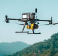
• Multispectral Imaging System: Equipped with both a multispectral camera and an RGB camera, for detailed analysis of vegetation health and crop growth.

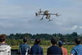
• Extended Flight Time: Maximum flight time of up to 43 minutes

• RTK Positioning: Incorporates Real-Time Kinematic (RTK) positioning technology for precise geolocation data essential for mapping and surveying applications.

• Obstacle Avoidance Sensors: Omnidirectional obstacle avoidance sensors ensure safe flight operations in challenging environments.

• High-Resolution Imaging: 20 MP RGB camera with mechanical shutter for quality imagery.

• Vegetation Index Mapping: Capable of generating vegetation index maps, such as NDVI (Normalized Difference Vegetation Index), for crop health assessment.

• Long-range Transmission: Utilizes O3 transmission technology for long-range data transmission up to 5 km.

Discover

the Measur Advantage

Find the perfect solution for your needs.

Reduce Expenses

Drones in forestry cut costs via early issue detection, expedited data collection, improved resource allocations, safety enhancements, and decision support. 


Increase Efficiency

Drones enable quick and cost-effective aerial surveillance, detecting issues like disease outbreaks or illegal logging early on. They streamline operations, optimize resource allocation, and provide valuable insights, ultimately enhancing efficiency in forestry management.

LiDAR Mapping

Mounted on drones, LiDAR emits laser pulses to measure distances to the Earth's surface, providing detailed terrain maps and precise information about forest structure. It enables analysis of canopy height, density, and individual tree identification, aiding in forest inventory, health assessment, and wildfire risk evaluation.

Enhanced Data Accuracy and Collection

Drones gather high-resolution imagery and other data with precision, providing accurate information for forest inventory, health assessments, and environmental monitoring. The time savings associated with drone-collected data facilitates timely analysis and informed management decisions, ultimately improving forest management practices.

With its high-endurance flight time of up to 55 minutes and robust weather-resistant design, the Matrice 350 RTK excels in conducting extensive aerial surveys of forested areas, allowing for comprehensive monitoring of forest health, biodiversity, and environmental conditions. Its advanced transmission system ensures stable communication and real-time data transfer, enabling forestry professionals to gather accurate information over large and often remote forested landscapes.


Additionally, the Matrice 350 RTK's high-precision mapping features, including Waypoint and Mapping missions, enable detailed mapping of forested terrain, providing valuable data for forest inventory, habitat assessment, and land-use planning. 

Key Features

• High Endurance and Weather Resistance: Long flight times (up to 55 minutes) allow for extended aerial surveys and monitoring sessions, crucial for large-scale forestry areas.


IP55 protection rating ensures reliable operation in varying environmental conditions commonly encountered in forestry settings.


High-Precision Mapping: Supports mapping missions such as Waypoint, Oblique, and Linear Flight, enabling detailed aerial surveys of forested areas.

Terrain Follow and Smart Oblique features optimize data collection in challenging terrain, providing accurate topographic information for forestry management tasks.


Obstacle Detection and Avoidance: 6-Directional Sensing & Positioning and CSM Radar systems offer comprehensive obstacle detection capabilities, crucial for navigating dense forest environments safely.

Advanced obstacle detection features minimize the risk of collisions with trees or other obstacles during flight, ensuring the safety of both the drone and surrounding forestry assets.


• Night-Vision FPV Camera:

The night-vision capabilities of the FPV camera enable clear visibility of the surroundings during nighttime flights, facilitating nocturnal monitoring activities common in forestry management.


Max flight altitude of 7000m

Multispectral & Thermal Sensors for the DJI M350 RTK

The Sentera 6X Multispectral Sensorprovides forestry professionals with a powerful tool for monitoring and managing forest health. With its high-resolution visual and multi-band capabilities, the sensor enables precise analysis of vegetation conditions, including detecting diseases, assessing weed pressure, and evaluating nutritional status. Real-time onboard image registration and analytics provide immediate insights, while drone compatibility facilitates efficient data collection over large forested areas.

By providing pixel-level absolute temperature and spectral reflectance measurements, the Sentera 6X thermal offers reliable data crucial for fieldwork. This sensor's radiometric calibration ensures consistency for repeatable measurements. With its advanced capabilities, including a 320 x 256 resolution longwave infrared thermal camera, four precision-filtered 3.2MP global-shutter imagers, and one 20.1MP RGB imager, each with dedicated, high-quality optical paths, the 6X Thermal facilitates comprehensive forestry analysis.

Forestry Mapping Using LiDAR

The YellowScan Surveyor Ultra  LiDAR system is a powerful tool for forestry mapping, offering high-density point clouds and advanced features tailored to the needs of the industry. With its precision of 3 cm and accuracy of 2.5 cm, it excels at capturing terrain details and vegetation characteristics crucial for forestry analysis. The system's 360° field of view, provided by the Hesai XT32M2X Laser Scanner, enables comprehensive data collection not only from the ground but also from vertical surfaces, such as trees. Its lightweight design, weighing only 983 g without batteries, facilitates easy mounting on various UAV platforms, including the DJI M350 RTK ensuring efficient aerial surveys of large forestry areas.

Key Features

• High Density LiDAR: Utilizes Hesai XT32M2X scanner for high-density data collection.

• 360° Field of View: Offers comprehensive coverage for vertical and mobile mapping needs.

Lightweight Design: Weighs 983 g without batteries, making it easy to mount on UAVs.

Integrated Camera: Includes an embedded camera for colorization purposes.

Advanced Data Processing: Enables fast processing for 3D modelling under vegetation.

Mobile Mapping Compatibility: Can be used for mobile mapping with YellowScan Fly&Drive kit.

Precision and Accuracy: Offers 3 cm precision and 2.5 cm accuracy.

Long Range Capabilities: Range of up to 80m, suitable for long-range mapping needs.

Drone Training


Whether you need one-on-one or group training, our training programs provide the latest practical knowledge while keeping your budget in mind.

Drone Rentals

Looking to rent a drone to meet your evolving drone needs?


You'll find a wide range of industry-leading equipment, from DJI drones to advanced LiDAR systems at Measur. We offer cost-effective and convenient solutions for accessing high-quality drone technology without the commitment of ownership. 

Get in touch

Give us a call or drop by anytime, we will answer all enquiries within 24 hours on business days. We will be happy to answer your questions.

Contact Information

We would love to hear from you! Our team is always here to help.

  • +1 866 300 9012

  • contact@measur.ca

  • Vancouver, British Columbia

    Calgary, Alberta

    Mississauga, Ontario

    Montreal, Quebec

Name*:

Phone*:

Email*:

Message:

CONTACT US

Name:

Company name:

Phone:

Email:

Message:

SPEAK WITH AN EXPERT

Name:

Company name:

Phone:

Email:

Message:

BACK TO TOP