No Products in the Cart
Locating pipes and utilities underground can be a difficult and time-consuming task, particularly in areas where the terrain is rugged or heavily vegetated. Traditionally, this has been accomplished through the use of Ground Penetrating Radar (GPR) systems, which allow operators to identify subsurface structures by detecting differences in the electrical conductivity of different materials. However, this process can be labour-intensive and requires a significant amount of time and effort to collect and analyze the data.
Fortunately, recent advances in drone technology have made it possible to integrate GPR systems with unmanned aerial vehicles (UAVs), offering a faster and more efficient way to locate pipes and other subsurface utilities. By using a drone equipped with a GPR system, operators can quickly and easily survey large areas and collect data with unprecedented speed and accuracy.
One of the key benefits of using a drone for underground mapping is that it allows operators to easily navigate difficult and remote terrain and avoid obstacles that might impede a ground-based survey.
Another benefit of using a drone for underground mapping is that it allows for more frequent and detailed surveys than would be possible with traditional ground-based methods. Because drones are able to cover large areas quickly and efficiently, they can be used to collect data on a regular basis, allowing operators to monitor changes in the subsurface environment over time.
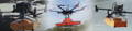
To use a drone for underground mapping, operators should select a system that is capable of providing the level of detail and accuracy required for their specific application. SPH Engineering has developed integrated solutions including ground penetrating systems that seamlessly integrate with the DJI M350 RTK, such as The Zond Aero 500, featuring:
- Operating bandwidth: 200-900 MHz (-12 dB)
- Samples: 512 per trace
- Sample rate: 25,600 samples/second
- Scan rate: 50 scans/s
- Sample output: 16 bit digital raw data
- Selectable time range: 50, 100, 200 or 300ns
- Depth: Up to 4 meters in average normal soil with 100ns time range
To use the integrated system, operators fly the drone over the survey area in a predetermined pattern, using the GPR system to collect data as they go. Once the survey is complete, the data can be downloaded and analyzed using specialized software to create a map of subsurface structures and utilities.
Additionally, UAV ground penetrating systems is an indispensable tool for the following industries:
By revealing stratigraphic architecture, sand-body geometry, and sedimentary structures, providing valuable information for geological research and exploration.
By measuring ice and snow thickness, supra glacial debris thickness, and ice core glacial-interglacial cycles, providing insights into glaciology and climate change.
By uncovering sinkholes, cavities, groundwater depths, and groundswells, providing valuable information for geotechnical surveys.
By helping find rocks, fractures, shear zones, faults, joints, and depth to bedrock, making it easier to explore and extract minerals from the earth.
By searching for artifacts, foundations, caves, tombs, tunnels, and voids, providing valuable information for archaeological research.
By detecting buried evidence of graves, caches of weapons, drugs, and money, making it easier for law enforcement officials to conduct investigations.
By evaluating as-built concrete components such as slabs, walls, columns, and beams, providing valuable information for engineers and construction professionals.
GPR systems integrated with drones can help expose buried unexploded ordnance (UXO), bunkers, tunnels, and objects behind structures, making it easier for military and law enforcement personnel to conduct operations.
Drone-mounted GPR systems can cover a larger area than a traditional GPR systems, making it possible to locate multiple objects in a single flight. The GPR system can be programmed to collect data automatically, and the data can be processed in real-time using specialized software to create 3D models and maps of the underground infrastructure.
For more information about drone GPR, contact us today.
Give us a call or drop by anytime, we will answer all enquiries within 24 hours on business days. We will be happy to answer your questions.
We would love to hear from you! Our team is always here to help.
+1 866 300 9012
contact@measur.ca
Vancouver, British Columbia
Calgary, Alberta
Mississauga, Ontario
Montreal, Quebec