No Products in the Cart


| SYSTEM | |
|---|---|
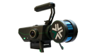
| Durability | Built to IP-67 standards |
| Weight (incl. battery) | 3.1kg |
| Weight (w/o battery) | 2.4kg |
| Size (H x W x L) | 104 mm x 180 mm x 361 mm |
| Operating Temperature | -20° to 45° C |
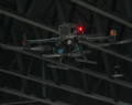
| Platform modularity | Drone/vehicle/backpack-mount, handheld |
| CAPABILITIES | |
| GPS-Required | No (GPS-optional) |
| Low/No-Light Operation | ✓ |
| Drone Autonomy | License Purchased Separately |
| Ground Autonomy | License Purchased Separately |
| GIMBALLED LIDAR | |
| Laser Safety Class | 1 |
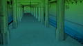
| Field Of View | 360° horizontal |
| Rotation Frequency | 10 Hz |
| Gimbal Rotation | ~1Hz |
| Max Range | 300 m @ 80% Surface Reflectance |
| Points Per Second | ~2,000,000 |
| Return Type | Triple with Intensity |
| OUTPUT | |
| Real-Time Data Visualization | ✓ |
| Data Collection Replay | ✓ |
| Point Cloud Colorization | ✓ |
| Point Cloud | XYZ, RGB, Intensity |
| Point Cloud Formats | LAS, PLY, XYZ |
| Other Outputs | Trajectory |
| Map Accuracy | ±5 mm |
| RGB CAMERAS | |
| Model | FLIR Blackfly |
| Field of View | 220o |
| # of Cameras | 2 |
| Megapixels | 3.2MP |
| CONTROL UNIT | |
| CPU | Intel Core i7 |
| RAM | 64GB DDR4 |
| Storage | 512GB internal SSD |
| Interfaces | USB 3.0, WiFi |
| POWER | |
| DC Input | 12-48 V |
| Power | 75 W |
| BATTERY* | |
| Batteries Included | 2 |
| Nominal Voltage | 14.8V |
| Battery Standard | V-Mount |
| Battery Capacity (each) | 98 Wh |
| Battery Chemistry Type | Li-Ion |
| Typical Operating Time | ~2 hours |
| TABLET | |
| Model | Dell Latitude 7230 12’, IP-65 |
| Interface | Capacitive Touchscreen |
| Operating System | Ubuntu 22.04 |
| Software Interface | ExynViewTM, mission control & live data streams |
| Communication | 2.4GHz & 5.8GHz WiFi WPA2 encryption |
| Weight | 1.3kg |
| CASE | |
| External Size (H x W x L) | 28 x 41 x 53.4 cm |
| Shipping Weight | 20.5 kg |
| ACCESSORIES* | |
| Hand-carry Mount | ✓ |
| Industrial Vehicle Mount | ✓ |
| Drone Mount | Purchased Separately |
| BackPak Case + Mount | Purchased Separately |
| Protective Cage | Purchased Separately |
| GPS-receiver | Purchased Separately |
